
Description
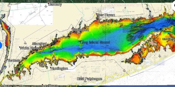
Long Island Sound fishing map 3D with high resolution images of the seafloor.
**Preview map is LOW RESOLUTION. See gallery below for HD sample images**
- : Long Island Sound fishing map features high definition 3D images of the seafloor.
- Location: Long Island Sound fishing chart coverage includes from Manhattan to Gardiner’s Point including Oyster, Huntington, Northpoint, Gardiner’s, Shelter Island, Peconic and other bays and sounds.
- Fishing Map Size: 220 square miles of potential fishing spots.
- Depths: Shoreline to 230 ft
- Works on: Lowrance, Simrad, Raymarine, B&G, VesselView, iPhone, iPad, and Android tablet.
- Resolution: Varies depending on the quality of data available.
- Notes: With StrikeLines’ HD view of the ocean floor you’ll see exactly where those potential fishing spots are on the map. See where the hundreds of wrecks, rock areas, and other areas of interest are in realtime on your GPS unit, mobile device, or computer.
- Updated: 4/9/2021: High resolution areas expanded west. Shading improved. NOAA underlay added for depths.
Reviews
There are no reviews yet.